Zealandia: Earth’s Hidden Continent
by The Geological Society of America, Inc.
Table of Contents
- Introduction
- Zealandia as a Continent
- Discussion and Implications
- Conclusions
- Acknowledgments
- References Cited
Search GoogleScholar for
- N Mortimer
- HJ Campbell
- AJ Tulloch
- PR King
- V Stagpoole
- RA Wood
- MS Rattenbury
- R Sutherland
- CJ Adams
- J Collot
- M Seton
Search GSA Today

Abstract
A 4.9 Mkm2 region of the southwest Pacific Ocean is made up of continental crust. The region has elevated bathymetry relative to surrounding oceanic crust, diverse and silica-rich rocks, and relatively thick and low-velocity crustal structure. Its isolation from Australia and large area support its definition as a continent—Zealandia. Zealandia was formerly part of Gondwana. Today it is 94% submerged, mainly as a result of widespread Late Cretaceous crustal thinning preceding supercontinent breakup and consequent isostatic balance. The identification of Zealandia as a geological continent, rather than a collection of continental islands, fragments, and slices, more correctly represents the geology of this part of Earth. Zealandia provides a fresh context in which to investigate processes of continental rifting, thinning, and breakup.
Manuscript received 12 Sept. 2016; Revised manuscript received 19 Dec. 2016; Manuscript accepted 21 Dec. 2016
doi: 10.1130/GSATG321A.1
Introduction
Earth’s surface is divided into two types of crust, continental and oceanic, and into 14 major tectonic plates (Fig. 1; Holmes, 1965; Bird, 2003). In combination, these divisions provide a powerful descriptive framework in which to understand and investigate Earth’s history and processes. In the past 50 years there has been great emphasis and progress in measuring and modeling aspects of plate tectonics at various scales (e.g., Kearey et al., 2009). Simultaneously, there have been advances in our understanding of continental rifting, continent-ocean boundaries (COBs), and the discovery of a number of micro-continental fragments that were stranded in the ocean basins during supercontinent breakups (e.g., Buck, 1991; Lister et al., 1991; Gaina et al., 2003; Franke, 2013; Eagles et al., 2015). But what about the major continents (Fig. 1)? Continents are Earth’s largest surficial solid objects, and it seems unlikely that a new one could ever be proposed.
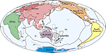 Figure 1
Simplified map of Earth’s tectonic plates and continents, including Zealandia. Continental shelf areas shown in pale colors. Large igneous province (LIP) submarine plateaus shown by blue dashed lines: AP—Agulhas Plateau; KP—Kerguelen Plateau; OJP—Ontong Java Plateau; MP—Manihiki Plateau; HP—Hikurangi Plateau. Selected microcontinents and continental fragments shown by black dotted lines: Md—Madagascar; Mt—Mauritia; D—Gulden Draak; T—East Tasman; G—Gilbert; B—Bollons; O—South Orkney. Hammer equal area projection.
The Glossary of Geology defines a continent as “one of the Earth’s major land masses, including both dry land and continental shelves” (Neuendorf et al., 2005). It is generally agreed that continents have all the following attributes: (1) high elevation relative to regions floored by oceanic crust; (2) a broad range of siliceous igneous, metamorphic, and sedimentary rocks; (3) thicker crust and lower seismic velocity structure than oceanic crustal regions; and (4) well-defined limits around a large enough area to be considered a continent rather than a microcontinent or continental fragment. The first three points are defining elements of continental crust and are explained in many geoscience textbooks and reviews (e.g., Holmes, 1965; Christensen and Mooney, 1995; Levander et al., 2005; Kearey et al., 2009; Condie, 2015). To our knowledge, the last point—how “major” a piece of continental crust has to be to be called a continent—is almost never discussed, Cogley (1984) being an exception. Perhaps this is because it is assumed that the names of the six geological continents—Eurasia, Africa, North America, South America, Antarctica, and Australia—suffice to describe all major regions of continental crust.
The progressive accumulation of bathymetric, geological, and geophysical data since the nineteenth century has led many authors to apply the adjective continental to New Zealand and some of its nearby submarine plateaus and rises (e.g., Hector, 1895; Hayes, 1935; Thomson and Evison, 1962; Shor et al., 1971; Suggate et al., 1978). “New Zealand” was listed as a continent by Cogley (1984), but he noted that its continental limits were very sparsely mapped. The name Zealandia was first proposed by Luyendyk (1995) as a collective name for New Zealand, the Chatham Rise, Campbell Plateau, and Lord Howe Rise (Fig. 2). Implicit in Luyendyk’s paper was that this was a large region of continental crust, although this was only mentioned in passing and he did not characterize and define Zealandia as we do here.
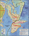 Figure 2
Spatial limits of Zealandia. Base map from Stagpoole (2002) based on data from Smith and Sandwell (1997). Continental basement samples from Suggate et al. (1978), Beggs et al. (1990), Tulloch et al. (1991, 2009), Gamble et al. (1993), McDougall et al. (1994), and Mortimer et al. (1997, 1998, 2006, 2008a, 2008b, 2015). NC—New Caledonia; WTP—West Torres Plateau; CT—Cato Trough; Cf—Chesterfield Islands; L—Lord Howe Island; N—Norfolk Island; K—Kermadec Islands; Ch—Chatham Islands; B—Bounty Islands; An—Antipodes Islands; Au—Auckland Islands; Ca—Campbell Island. Mercator projection.
In this paper we summarize and reassess a variety of geoscience data sets and show that a substantial part of the southwest Pacific Ocean consists of a continuous expanse of continental crust. Furthermore, the 4.9 Mkm2 area of continental crust is large and separate enough to be considered not just as a continental fragment or a microcontinent, but as an actual continent—Zealandia. This is not a sudden discovery but a gradual realization; as recently as 10 years ago we would not have had the accumulated data or confidence in interpretation to write this paper. Since it was first proposed by Luyendyk (1995), the use of the name Zealandia for a southwest Pacific continent has had moderate uptake (e.g., Mortimer et al., 2006; Grobys et al., 2008; Segev et al., 2012; Mortimer and Campbell, 2014; Graham, 2015). However, it is still not well known to the broad international science community. A correct accounting of Earth’s continents is important for multiple fields of natural science; the purpose of this paper is to formally put forth the scientific case for the continent of Zealandia (Figs. 1 and 2) and explain why its identification is important.
Zealandia as a Continent
New Zealand and New Caledonia are large, isolated islands in the southwest Pacific Ocean. They have never been regarded as part of the Australian continent, although the geographic term Australasia often is used for the collective land and islands of the southwest Pacific region. In the following sections, we summarize the four key attributes of continents and assess how Zealandia meets these criteria.
Elevation
Continents and their continental shelves vary in height but are always elevated relative to oceanic crust (Cogley, 1984). The elevation is a function of many features, fundamentally lithosphere density and thickness, as well as plate tectonics (e.g., Kearey et al., 2009). The existence of positive bathymetric features north and south of New Zealand has been known for more than a century (Farquhar, 1906). The accuracy and precision of seafloor mapping have improved greatly over the past decades (Brodie, 1964; Smith and Sandwell, 1997; Stagpoole, 2002) and a deliberately chosen color ramp on a satellite gravity-derived bathymetry map provides an excellent visualization of the extent of continental crust (Fig. 2). The approximate edge of Zealandia can be placed where the oceanic abyssal plains meet the base of the continental slope, at water depths between 2500 and 4000 m below sea level. The precise position of the foot of the continental slope around Zealandia was established during numerous surveys in support of New Zealand’s Law of the Sea submission (Wood et al., 2003; UNCLOS, 2008).
Zealandia is everywhere substantially elevated above the surrounding oceanic crust. The main difference with other continents is that it has much wider and deeper continental shelves than is usually the case (Fig. 1). Zealandia has a modal elevation of ~−1100 m (Cogley, 1984) and is ~94% submerged below current sea level. The highest point of Zealandia is Aoraki–Mount Cook at 3724 m.
Geology
By itself, relatively high elevation is not enough to establish that a piece of crust is continental. Oceanic large igneous provinces such as the Ontong Java Plateau (Fig. 1; Coffin and Eldholm, 1994) are elevated but not continental. Rocks of the modern oceanic crust typically comprise basalt and gabbro of Jurassic to Holocene age. In contrast, continents have diverse assemblages of Archean to Holocene igneous, metamorphic, and sedimentary rocks, such as granite, rhyolite, limestone, quartzite, greywacke, schist, and gneiss, arranged in orogenic belts and sedimentary basins.
Essential geological ground truth for Zealandia is provided by the many island outcrop, drill core, xenolith, and seabed dredge samples of Paleozoic and Mesozoic greywacke, schist, granite, and other siliceous continental rocks that have been found within its limits (Fig. 2). Many of these have been obtained from expeditions in the past 20 years (see Fig. 2, caption). Orogenic belts, of which the Median Batholith and Haast Schist are parts, can be tracked through onland New Zealand and across Zealandia (Fig. 2). Thus, there is a predictable regional coherency and continuity to the offshore basement geology.
Traditionally, continents have been subdivided into cratons, platforms, Phanerozoic orogenic belts, narrow rifts, and broad extensional provinces (Levander et al., 2005). Eurasia, Africa, North America, South America, Antarctica, and Australia all contain Precambrian cratons. The oldest known rocks in Zealandia are Middle Cambrian limestones of the Takaka Terrane and 490–505 Ma granites of the Jacquiery Suite (Mortimer et al., 2014). Precambrian cratonic rocks have not yet been discovered within Zealandia, but their existence has been postulated on the basis of Rodinian to Gondwanan age detrital zircon ratios (Adams and Griffin, 2012). Furthermore, some Zealandia mantle xenoliths give Re-Os ages as old as 2.7 Ga (Liu et al., 2015). Geologically, Zealandia comprises multiple Phanerozoic orogenic belts on which a broad extensional province and several narrow rift zones have been superimposed (Mortimer and Campbell, 2014).
Atop its geological basement rocks, Zealandia has a drape of at least two dozen spatially separate Late Cretaceous to Holocene sedimentary basins. These typically contain 2–10-km-thick sequences of terrigenous and calcareous strata (Zealandia Megasequence of Mortimer et al., 2014) and include a widespread continental breakup unconformity of ca. 84 Ma age (Bache et al., 2014). The Zealandia Megasequence provides a Zealandia-wide stratigraphic record of continental rifting, and marine transgression events, similar to that seen in formerly conjugate east Australian basins (Blewett, 2012).
Crustal Structure
Continental crust varies considerably in thickness and physical properties. Christensen and Mooney (1995) give an average P wave velocity of 6.5 km−1 and mean density of 2830 kgm−3 with an average thickness of 46 km for orogens and 30 km for extended crust. In contrast, oceanic crust is typically 7 km thick, and, in its lower part typically has a P wave velocity of 7.5 km−1 (White et al., 1992).
From geophysical work, we know that Zealandia has a continental crust velocity structure, Vp, generally <7.0 km−1, and a thickness typically ranging from 10 to 30 km throughout its entire extent to >40 km under parts of South Island (Shor et al., 1971; Klingelhoefer et al., 2007; Grobys et al., 2008; Eberhart-Phillips et al., 2010; Segev et al., 2012). Whereas most of Zealandia’s crust is thinner than the 30–46 km that is typical of most continents, the above studies show that it is everywhere thicker than the ~7-km-thick crust of the ocean basins. This result is visible in the global CRUST1.0 model of Laske et al. (2013) shown in Figure 3. Collectively, the crustal structure results show that the rock samples of Figure 2 are not from separate continental fragments or blocks now separated by oceanic crust, but are from a single continental mass.
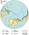 Figure 3
Present day map of CRUST1.0 crustal thickness (Laske et al., 2013) showing the dispersed Gondwana continents of Australia, Zealandia, East and West Antarctica, and South America. Note thin continental crust in vicinity of Mesozoic arc. M—Marion Plateau; R—Ross Sea; W—Weddell Sea; F—Falkland-Malvinas Plateau. LIP abbreviations: KP—Kerguelen Plateau; OJP—Ontong Java Plateau; MP—Manihiki Plateau; HP—Hikurangi Plateau. Thick coastlines in Antarctica are isostatically corrected ice-free coastlines (Jamieson et al., 2014). Orthographic projection.
The thinnest crust within Zealandia is in the 2200-km-long and 200–300-km-wide New Caledonia Trough, where the water depth varies from 1500 to 3500 m (Fig. 2). This raises the question as to whether the trough is floored by oceanic crust or is a failed continental rift. Two wide-angle seismic profiles across the trough near New Caledonia (Klingelhoefer et al., 2007) both show ~2–5 km of sedimentary cover over 8.5 km of crustal basement that has a velocity of ~7 km−1 throughout much of its thickness. Klingelhoefer et al. (2007) noted these profiles as atypical of normal oceanic crust. Sutherland et al. (2010) and Hackney et al. (2012) interpreted the New Caledonia Trough as continental crust that was thinned in the Late Cretaceous and re-deepened in the Eocene due to lithosphere delamination.
Limits and Area
Where oceanic crust abuts continental crust, various kinds of continent-ocean boundaries (COBs) define natural edges to continents (Fig. 1; Eagles et al., 2015). Despite its large area, Greenland is uncontroversially and correctly regarded as part of North America (Figs. 1 and 4). This is because, despite oceanic crust intervening between southern Greenland and Labrador and Baffin Island, North American continental geology is continuous across Nares Strait between northernmost Greenland and Ellesmere Island (Pulvertaft and Dawes, 2011). Tectonic plate boundaries, with or without intervening oceanic crust, provide the basis for continent-continent boundaries between Africa and Eurasia, and North and South America (Fig. 1). Large area is an inherent part of the definition of a continent sensu stricto (Neuendorf et al., 2005). Cogley (1984) defined Central America (1.3 Mkm2), Arabia (4.6 Mkm2), and greater India (4.6 Mkm2) as modern-day continents. This schema has not been generally adopted, probably because Central America (the Chortis block) is a piece of displaced North America, and Arabia and India are transferring to, and are now contiguous with, Eurasia and have clearly defined COBs in the Red Sea and Indian Ocean (Fig. 1). The six commonly recognized geological continents (Africa, Eurasia, North America, South America, Antarctica, and Australia) are thus not only large but they are also spatially isolated by geologic and/or bathymetric features.
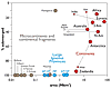 Figure 4
Areas and submergence of all of Earth’s geological continents (red symbols) along with microcontinents (brown symbols) and intraoceanic large igneous provinces (LIPs, blue symbols) shown in Figures 1 and 2. Note x-axis is log scale. Data mainly after Cogley (1984) except Zealandia data from Mortimer and Campbell (2014); microcontinents after Gaina et al. (2003) and Torsvik et al. (2013). Emergent land area for Antarctica is the isostatically-corrected ice-free bedrock surface from Jamieson et al. (2014). New Guinea and Greenland are arbitrarily given the same submergence value as their parent continents. AP—Agulhas Plateau; KP—Kerguelen Plateau; OJP—Ontong Java Plateau; MP—Manihiki Plateau; HP—Hikurangi Plateau; N Am—North America; S Am—South America.
At the other end of the size spectrum, a number of continental crust fragments in the world’s oceans are referred to as microcontinents. Examples include the Madagascar, East Tasman, Jan Mayen, Mauritia, and Gulden Draak microcontinents (Gaina et al., 2003; Torsvik et al., 2013; Whittaker et al., 2016). Discriminating between what is a continent and what is a microcontinent may be considered an arbitrary exercise. Nonetheless, maps like Figure 1 need labels. Therefore, following Cogley (1984) and the vagaries of general conventional usage, we propose that the name continent be applied to regions of continental crust that are >1 Mkm2 in area and are bounded by well-defined geologic limits. By this definition India, prior to its collision with Eurasia, would be termed a continent.
The edges of Australia and Zealandia continental crust approach to within 25 km across the Cato Trough (Fig. 2). The Cato Trough is 3600 m deep and floored by oceanic crust (Gaina et al., 1998; Exon et al., 2006). The Australian and Zealandian COBs here coincide with, and have been created by, the Cato Fracture Zone along which there has been ~150 km of dextral strike slip movement, linking Paleogene spreading centers in the Tasman and Coral seas (Fig. 2; Gaina et al., 1998). This spatial and tectonic separation, along with intervening oceanic crust, means that the Zealandia continental crust is physically separate from that of Australia. If the Cato Trough did not exist, then the content of this paper would be describing the scientific advance that the Australian continent was 4.9 Mkm2 larger than previously thought.
Being >1 Mkm2 in area, and bounded by well-defined geologic and geographic limits, Zealandia is, by our definition, large enough to be termed a continent. At 4.9 Mkm2, Zealandia is substantially bigger than any features termed microcontinents and continental fragments, ~12× the area of Mauritia and ~6× the area of Madagascar (Fig. 4). It is also substantially larger than the area of the largest intraoceanic large igneous province, the Ontong Java Plateau (1.9 Mkm2). Zealandia is about the same area as greater India (Figs. 1 and 4). Figure 4 makes a case for a natural twofold grouping of continents and microcontinents.
Discussion and Implications
Recognition
Satellite gravity-derived bathymetry maps (e.g., Fig. 2) have been of immense use in visualizing Zealandia, clarifying its limits, focusing attention on intra-Zealandia structures, and planning research voyages. If the elevation of Earth’s solid surface had first been mapped in the same way as those of Mars and Venus (which lack the arbitrary datums of opaque liquid oceans), we contend that Zealandia would, much earlier, have been investigated and identified as one of Earth’s continents. Even relatively recently, some papers refer to the offshore ridges and plateaus of Zealandia as an amalgam of continental fragments and slivers (e.g., Gaina et al., 2003; Blewett, 2012; Higgins et al., 2015) with the explicit or implicit notion that oceanic crust intervenes between the continental fragments. The way in which Zealandia has been divided into blocks to make it amenable to rigid plate reconstructions and the way in which coastlines and outlines have been drafted as “floating” in the Pacific Ocean (e.g., Gaina et al., 1998, 2003; Lisker and Läufer, 2013; Higgins et al., 2015) has probably sustained this false impression of remote and discombobulated tectonic allochthony and poorly defined COBs. In contrast, we view Zealandia as a coherent, albeit thinned and stretched, continent with interconnected and throughgoing geological provinces (Figs. 2 and 5; Mortimer et al., 2006; Grobys et al., 2008; Tulloch et al., 2009; Adams and Griffin, 2012; Bache et al., 2014; Graham, 2015). Like parts of North America and Eurasia, Zealandia has undergone active deformation in a zone between two essentially rigid plates—in Zealandia’s case, the Pacific and Australian (Fig. 2).
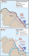 Figure 5
Zealandia as part of the former Gondwana supercontinent. Upper panel shows Mesozoic orogen convergent margin that was active until ca. 105 Ma. Lower panel shows pre-breakup intracontinental extension of Zealandia and West Antarctica from 105 to 85 Ma; seafloor spreading subsequently split Gondwana into its present-day constituent continents (Fig. 3). Orthographic projections with East Antarctica fixed. From Mortimer and Campbell (2014).
Several elevated bathymetric features north of Zealandia are possible candidates for Zealandia prolongations or separate microcontinents (Fig. 2). These include the Three Kings, Lau-Colville, and Tonga-Kermadec ridges and Fiji, which are known Cenozoic volcanic arcs (Graham, 2015), and the Mellish Rise and Louisiade and West Torres plateaus. However, no continental basement rocks have yet been sampled from any of these features, so their continental nature remains unproven.
Development and Submergence
As shown in Figure 4, ~94% of the area of Zealandia currently is submerged. It is not unique in this regard: an ice-free, isostatically corrected West Antarctica would also largely be submerged (Figs. 3 and 4; Jamieson et al., 2014). Zealandia and West Antarctica were formerly adjacent to each other along the southeast Gondwana margin and, prior to thinning and breakup, the orogenic belts, Cordilleran batholiths, and normal continental crustal thickness of eastern Australia would have projected along strike into these areas (Figs. 3 and 5). Several continental metamorphic core complexes (Lister and Davis, 1989) of Late Cretaceous age have been identified in Zealandia and West Antarctica, but not in Australia or East Antarctica (Figs. 3 and 5; Kula et al., 2007). These have been explained by Lister et al. (1991) and Kula et al. (2007) in terms of an asymmetric continent-scale detachment fault model in which Zealandia and West Antarctica are highly extended, lower-plate passive continental margins, and Australia and East Antarctica are relatively unstretched upper plate margins. There is also abundant supporting sedimentary basin evidence that Zealandia experienced widespread Late Cretaceous (ca. 105–85 Ma) extension prior to Gondwana supercontinent breakup (e.g., Luyendyk, 1995; Klingelhoefer et al., 2007; Bache et al., 2014; Mortimer et al., 2014; Higgins et al., 2015). The situation of Zealandia’s Phanerozoic orogen overlying Precambrian mantle (Liu et al., 2015) possibly suggests major tectonic detachments along the Moho.
Thermal relaxation and isostatic balance of the thinned continental crust of Zealandia and West Antarctica ultimately led to their submergence. Despite the pervasive thinning, the only part of Zealandia that might qualify as a hyper-extended zone (i.e., stretched by a factor of 3–4 with crustal thinning to 8 km or less; Doré and Lundin, 2015) is the New Caledonia Trough. Zealandia and West Antarctica seemingly record a mode of continental crust deformation in which extension, although substantial, is more distributed and less focused than in most examples of continental breakup. Zealandia has a widespread syn-rift Late Cretaceous volcanic record (Tulloch et al., 2009; Mortimer et al., 2014); thus, processes that operate at volcanic rifted margins (Menzies et al., 2002) may be applicable to the broad area of Zealandia.
Significance
Zealandia once made up ~5% of the area of Gondwana. It contains the principal geological record of the Mesozoic convergent margin of southeast Gondwana (Mortimer et al., 2014) and, until the Late Cretaceous, lay Pacificward of half of West Antarctica and all of eastern Australia (Figs. 3 and 5). Thus, depictions of the Paleozoic-Mesozoic geology of Gondwana, eastern Australia, and West Antarctica are both incomplete and misleading if they omit Zealandia.
The importance of Zealandia is not so much that there is now a case for a formerly little-known continent, but that, by virtue of its being thinned and submerged, but not shredded into microcontinents, it is a new and useful continental end member. Zealandia started to separate from Gondwana in the Late Cretaceous as an ~4000-km-long ribbon continent (Fig. 5) but has since undergone substantial intracontinental deformation, to end up in its present shape and position (Figs. 1–3). To date, Zealandia is little-mentioned and/or entirely overlooked in comparative studies of continental rifting and of COBs (e.g., Buck, 1991; Menzies et al., 2002; Franke, 2013). By including Zealandia in investigations, we can discover more about the rheology, cohesion, and extensional deformation of continental crust and lithosphere.
Gondwana breakup along the paleo-Pacific margin resulted in continents with wide, thinned shelves, such as Zealandia and West Antarctica (Figs. 1 and 3). In contrast, breakup of Gondwana’s core resulted in continents with narrow shelves, such as Africa and its neighbors (Fig. 1). Various lithospheric versus mantle controls on styles of continental rifting and breakup are still debated (Ebinger and van Wijk, 2014; Whittaker et al., 2016). The broad spatial association of stretched continental crust with a pre-softened, Mesozoic, paleo-Pacific convergent margin from the Falkland Plateau, through West Antarctica and Zealandia to the Marion Plateau (Fig. 3), is possibly no coincidence (cf. Rey and Müller, 2010). Other proposed controls on the localization of Zealandia-Gondwana breakup include a mantle plume (Weaver et al., 1994), plate capture (Luyendyk, 1995), and/or impingement of an oceanic spreading ridge (Mortimer et al., 2006).
Gaina et al. (2003) proposed that microcontinents are created by plume-controlled ridge jumps during the early stages of supercontinent breakup. The general cohesion of continental crust in extension is attested to by the contrast in size between Zealandia and its neighboring continental fragments of East Tasman, Gilbert, and Bollons seamounts (Figs. 2 and 4). Condie (2015) postulated that ancient and modern continent-continent collisions were a leading cause of continental elevation. The geological history of Zealandia would support this hypothesis: The Paleozoic and Mesozoic orogens of Zealandia are non-collisional (Mortimer et al., 2014), and there is only incipient collision between northern and southern Zealandia across the present-day Pacific-Australian plate boundary. Ironically, for a continent so thoroughly shaped by extensional processes and subsidence, it is the more widely recognized and better-studied convergence across the Cenozoic Pacific-Australian plate boundary that has resulted in any of Zealandia being above the sea.
Conclusions
Zealandia illustrates that the large and the obvious in natural science can be overlooked. Based on various lines of geological and geophysical evidence, particularly those accumulated in the last two decades, we argue that Zealandia is not a collection of partly submerged continental fragments but is a coherent 4.9 Mkm2 continent (Fig. 1). Currently used conventions and definitions of continental crust, continents, and microcontinents require no modification to accommodate Zealandia.
Satellite gravity data sets, New Zealand’s UNCLOS program, and marine geological expeditions have been major influences in promoting the big picture view necessary to define and recognize Zealandia (Fig. 2). Zealandia is approximately the area of greater India and, like India, Australia, Antarctica, Africa, and South America, was a former part of the Gondwana supercontinent (Figs. 3 and 5). As well as being the seventh largest geological continent (Fig. 1), Zealandia is the youngest, thinnest, and most submerged (Fig. 4). The scientific value of classifying Zealandia as a continent is much more than just an extra name on a list. That a continent can be so submerged yet unfragmented makes it a useful and thought-provoking geodynamic end member in exploring the cohesion and breakup of continental crust.
Acknowledgments
We thank Belinda Smith Lyttle for GIS work and Patti Durance, Ron Hackney, and Brendan Murphy for comments. Formal reviews by Peter Cawood, Jerry Dickens, and an anonymous referee greatly improved the focus and content. This paper is based on work supported by New Zealand Government core funding grants to GNS Science.
References Cited
- Adams, C.J., and Griffin, W.L., 2012, Rodinian detrital zircons in Late Cretaceous sandstones indicate a possible Precambrian basement under southern Zealandia: Precambrian Research, v. 212–213, p. 13–20, doi: 10.1016/j.precamres.2012.04.003.
- Bache, F., Mortimer, N., Sutherland, R., Collot, J., Rouillard, P., Stagpoole, V.M., and Nicol, A., 2014, Seismic stratigraphic record of transition from Mesozoic subduction to continental breakup in the Zealandia sector of eastern Gondwana: Gondwana Research, v. 26, p. 1060–1078, doi: 10.1016/j.gr.2013.08.012.
- Beggs, J.M., Challis, G.A., and Cook, R.A., 1990, Basement geology of the Campbell Plateau: Implications for correlation of the Campbell Magnetic Anomaly System: New Zealand Journal of Geology and Geophysics, v. 33, p. 401–404, doi: 10.1080/00288306.1990.10425696.
- Bird, P., 2003, An updated digital model of plate boundaries: Geochemistry Geophysics Geosystems, v. 4, p 1027, doi: 10.1029/2001GC000252.
- Blewett, R.S., editor, 2012, Shaping a Nation:
- A Geology of Australia: Canberra, Geoscience Australia and ANU Press, 571 p.
- Brodie, J.W., 1964, Bathymetry of the New Zealand region: New Zealand Oceanographic Institute Memoir 11, 54 p.
- Buck, W.R., 1991, Modes of continental lithospheric extension: Journal of Geophysical Research, v. 96, p. 20,161–20,178, doi: 10.1029/91JB01485.
- Christensen, N.I., and Mooney, W.D., 1995, Seismic velocity structure and composition of the continental crust: A global view: Journal of Geophysical Research, v. 100, p. 9761–9788, doi: 10.1029/95JB00259.
- Coffin, M.F., and Eldholm, O., 1994, Large igneous provinces: Crustal structure, dimensions, and external consequences: Reviews of Geophysics, v. 32, p. 1–36, doi: 10.1029/93RG02508.
- Cogley, J.G., 1984, Continental margins and the extent and number of the continents: Reviews of Geophysics and Space Physics, v. 22, p. 101–122, doi: 10.1029/RG022i002p00101.
- Condie, K.C., 2015, Earth as an Evolving Planetary System, 3rd edition: Amsterdam, Elsevier, 350 p.
- Doré, D., and Lundin, E., 2015, Hyperextended continental margins—knowns and unknowns: Geology, v. 43, p. 95–96, doi: 10.1130/focus012015.1.
- Eagles, G., Pérez-Díaz, L., and Scarselli, N., 2015, Getting over continent ocean boundaries: Earth-Science Reviews, v. 151, p. 244–265, doi: 10.1016/j.earscirev.2015.10.009.
- Eberhart-Phillips, D., Reyners, M., Bannister, S., Chadwick, M., and Ellis, S., 2010, Establishing a versatile 3-D seismic velocity model for New Zealand: Seismological Research Letters, v. 81, p. 992–1000, doi: 10.1785/gssrl.81.6.992.
- Ebinger, C., and van Wijk, J., 2014, Roadmap to continental rupture: Is obliquity the route to success?: Geology, v. 42, p. 271–272, doi:10.1130/focus032014.1.
- Exon, N.F., Hill, P.J., Lafoy, Y., Heine, C., and Bernardel, G., 2006, Kenn Plateau off northeast Australia: A continental fragment in the southwest Pacific jigsaw: Australian Journal of Earth Sciences, v. 53, p. 541–564.
- Farquhar, H., 1906, The New Zealand Plateau: Transactions and Proceedings of the New Zealand Institute, v. 39, p. 135–137.
- Franke, D., 2013, Rifting, lithosphere breakup and volcanism: Comparison of magma-poor and volcanic rifted margins: Marine and Petroleum Geology, v. 43, p. 63–87, doi: 10.1016/j.marpetgeo.2012.11.003.
- Gaina, C., Müller, R.D., Royer, J.-Y., Stock, J.M., Hardebeck, J., and Symonds, P., 1998, The tectonic history of the Tasman Sea: A puzzle with 13 pieces: Journal of Geophysical Research, v. 103, p. 12,413–12,433, doi: 10.1029/98JB00386.
- Gaina, C., Müller, D., Brown, B.J., and Ishihara, T., 2003, Microcontinent formation around Australia, in Hillis, R., and Müller, R.D., eds., Evolution and Dynamics of the Australian Plate: Geological Society of Australia Special Publication v. 22, p. 405–416.
- Gamble, J.A., Wright, I.C., and Baker, J.A., 1993, Seafloor geology and petrology in the oceanic to continental transition zone of the Kermadec-Havre-Taupo Volcanic Zone arc system, New Zealand: New Zealand Journal of Geology and Geophysics, v. 36, p. 417–435, doi: 10.1080/00288306.1993.9514588.
- Graham, I.J., chief editor, 2015, A continent on the move: New Zealand geoscience revealed, 2nd edition: Wellington, New Zealand, Geoscience Society of New Zealand, 397 p.
- Grobys, J.W.G., Gohl, K., and Eagles, G., 2008, Quantitative tectonic reconstructions of Zealandia based on crustal thickness estimates: Geochemistry Geophysics Geosystems, v. 9, Q01005, doi: 10.1029/2007GC001691.
- Hackney, R., Sutherland, R., and Collot, J., 2012, Rifting and subduction initiation history of the New Caledonia Trough, southwest Pacific, constrained by process-oriented gravity models: Geophysical Journal International, v. 189, p. 1293–1305, doi: 10.1111/j.1365-246X.2012.05441.x.
- Hayes, R.C., 1935, Seismic waves and crustal structure in the New Zealand region: New Zealand Journal of Science and Technology, v. 17, p. 519–528.
- Hector, J., 1895, Note on the geology of the outlying islands of New Zealand: Transactions and Proceedings of the Royal Society of New Zealand, v. 28, p. 736–738.
- Higgins, K., Hashimoto, T., Rollet, N., Colwell, J., Hackney, R., and Milligan, P., 2015, Structural analysis of extended Australian continental crust: Capel and Faust basins, Lord Howe Rise, in Gibson, G.M., Roure, F., and Manatschal, G., eds., Sedimentary Basins and Crustal Processes at Continental Margins: From Modern Hyper-extended Margins to Deformed Ancient Analogues: Geological Society [London] Special Publication 413, p. 9–33.
- Holmes, A., 1965, Principles of physical geology, revised edition: London, Thomas Nelson, 1288 p.
- Jamieson, S.S.R., Stokes, C.R., Ross, N., Rippin, D.M., Bingham, R.G., Wilson, D.S., Margold, M., and Bentley, M.J., 2014, The glacial geomorphology of the Antarctic ice sheet bed: Antarctic Science, v. 26, p. 724–741, doi: 10.1017/S0954102014000212.
- Kearey, P., Klepeis, K.A., and Vine, F.J., 2009, Global Tectonics, 3rd edition: Chichester, U.K., Wiley-Blackwell, 482 p.
- Klingelhoefer, F., Lafoy, Y., Collot, J., Cosquer, E., Géli, L., Nouzé, H., and Vially, R., 2007, Crustal structure of the basin and ridge system west of New Caledonia (southwest Pacific) from wide-angle and reflection seismic data: Journal of Geophysical Research, v. 112, B11102, doi: 10.1029/2007JB005093.
- Kula, J.L., Tulloch, A.J., Spell, T.L., and Wells, M.L., 2007, Two-stage rifting of Zealandia-Australia-Antarctica: Evidence from 40Ar/39Ar thermochronometry of the Sisters shear zone, Stewart Island, New Zealand: Geology, v. 35, p. 411–414, doi: 10.1130/G23432A.1.
- Laske, G., Masters, G., Ma, Z., and Pasyanos, M., 2013, Update on CRUST1.0—A 1-degree global model of Earth’s crust: Geophysical Research Abstracts 15, Abstract EGU2013–2658.
- Levander, A., Lenardic, A., and Karlstrom, K., 2005, Structure of the continental lithosphere, in Brown, M., and Rushmer, T., eds., Evolution and differentiation of the continental crust: Cambridge University Press, p. 21–66.
- Lisker, F., and Läufer, A.L., 2013, The Mesozoic Victoria Basin, vanished link between Antarctica and Australia: Geology, v. 41, p. 1043–1046, doi: 10.1130/G33409.1.
- Lister, G.S., and Davis, G.A., 1989, The origin of metamorphic core complexes and detachment faults formed during Tertiary continental extension in the northern Colorado River region, U.S.A.: Journal of Structural Geology, v. 11, p. 65–94, doi: 10.1016/0191-8141(89)90036-9.
- Lister, G.S., Etheridge, M.A., and Symonds, P.A., 1991, Detachment models for the formation of passive continental margins: Tectonics, v. 10, p. 1038–1064, doi: 10.1029/90TC01007.
- Liu, J., Scott, J.M., Martin, C.E., and Pearson, D.G., 2015, The longevity of Archean mantle residues in the convecting upper mantle and their role in young continent formation: Earth and Planetary Science Letters, v. 424, p. 109–118, doi: 10.1016/j.epsl.2015.05.027.
- Luyendyk, B., 1995, Hypothesis for Cretaceous rifting of East Gondwana caused by subducted slab capture: Geology, v. 23, p. 373–376, doi: 10.1130/0091-7613(1995)023<0373:HFCROE>2.3.CO;2.
- McDougall, I., Maboko, M.A.H., Symonds, P.A., McCulloch, M.T., Williams, I.S., and Kudrass, H.R., 1994, Dampier Ridge, Tasman Sea, as a stranded continental fragment: Australian Journal of Earth Sciences, v. 41, p. 395–406, doi: 10.1080/08120099408728150.
- Menzies, M.A., Klemperer, S.L., Ebinger, C.J., and Baker, J., 2002, Characteristics of volcanic rifted margins, in Menzies, M.A., Klemperer, S.L., Ebinger, C.J., and Baker, J., eds., Volcanic Rifted Margins: Geological Society of America Special Paper 362, p. 1–14.
- Mortimer, N., and Campbell, H.J., 2014, Zealandia: Our continent revealed: Auckland, New Zealand, Penguin, 272 p.
- Mortimer, N., Tulloch, A.J., and Ireland, T.R., 1997, Basement geology of Taranaki and Wanganui basins, New Zealand: New Zealand Journal of Geology and Geophysics, v. 40, p. 223–236, doi: 10.1080/00288306.1997.9514754.
- Mortimer, N., Herzer, R.H., Gans, P.B., Parkinson, D.L., and Seward, D., 1998, Basement geology from Three Kings Ridge to West Norfolk Ridge, southwest Pacific Ocean: Evidence from petrology, geochemistry and isotopic dating of dredge samples: Marine Geology, v. 148, p. 135–162, doi: 10.1016/S0025-3227(98)00007-3.
- Mortimer, N., Hoernle, K., Hauff, F., Palin, J.M., Dunlap, W.J., Werner, R., and Faure, K., 2006, New constraints on the age and evolution of the Wishbone Ridge, southwest Pacific Cretaceous microplates, and Zealandia–West Antarctica breakup: Geology, v. 34, p. 185–188, doi: 10.1130/G22168.1.
- Mortimer, N., Hauff, F., and Calvert, A.T., 2008a, Continuation of the New England orogen, Australia, beneath the Queensland Plateau and Lord Howe Rise: Australian Journal of Earth Sciences, v. 55, p. 195–209, doi: 10.1080/08120090701689365.
- Mortimer, N., Dunlap, W.J., Palin, J.M., Herzer, R.H., Hauff, F., and Clark, M., 2008b, Ultra-fast early Miocene exhumation of Cavalli Seamount, Northland Plateau, Southwest Pacific Ocean: New Zealand Journal of Geology and Geophysics, v. 51, p. 29–42, doi: 10.1080/00288300809509848.
- Mortimer, N., and 22 others, 2014, High-level stratigraphic scheme for New Zealand rocks: New Zealand Journal of Geology and Geophysics, v. 57, p. 402–419, doi: 10.1080/00288306.2014.946062.
- Mortimer, N., Turnbull, R.E., Palin, J.M., Tulloch, A.J., Rollet, N., and Hashimoto, T., 2015, Triassic–Jurassic granites on the Lord Howe Rise, northern Zealandia: Australian Journal of Earth Sciences, v. 62, p. 735–742.
- Neuendorf, K.K.E., Mehl, J.P., and Jackson, J.A., 2005, Glossary of Geology, 5th edition: Alexandria, Virginia, American Geological Institute, 779 p.
- Pulvertaft, T.C.R., and Dawes, P.R., 2011, North Atlantic spreading axes terminate in continental cul-de-sacs of Baffin Bay and the Laptev Sea: Canadian Journal of Earth Sciences, v. 48, p. 593–601, doi: 10.1139/E11-004.
- Rey, P.F., and Müller, R.D., 2010, Fragmentation of active continental plate margins owing to the buoyancy of the mantle wedge: Nature Geoscience, v. 3, p. 2547–261.
- Segev, A., Rybakov, M., and Mortimer, N., 2012, A crustal model for Zealandia and Fiji: Geophysical Journal International, v. 189, p. 1277–1292, doi: 10.1111/j.1365-246X.2012.05436.x.
- Shor, G.G., Jr., Kirk, H.K., and Menard, H.W., 1971, Crustal structure of the Melanesian area: Journal of Geophysical Research, v. 76, p. 2562–2586, doi:10.1029/JB076i011p02562.
- Smith, W.H.F., and Sandwell, D.T., 1997, Global sea floor topography from satellite altimetry and ship depth soundings: Science, v. 277, p. 1956–1962, doi: 10.1126/science.277.5334.1956.
- Stagpoole, V.M., 2002, The New Zealand continent, version 1.0: Institute of Geological and Nuclear Sciences Geophysical Map GPM15, scale: 1:7,500,000.
- Suggate, R.P., Stevens, G.R., and Te Punga, M.T., eds., 1978, The geology of New Zealand: Wellington, New Zealand, Government Printer, 819 p.
- Sutherland, R., Collot, J., Lafoy, Y., Logan, G.A., Hackney, R., Stagpoole, V., Uruski, C., Hashimoto, T., Higgins, K., Herzer, R.H., Wood, R., Mortimer, N., and Rollet, N., 2010, Lithosphere delamination with foundering of lower crust and mantle caused permanent subsidence of New Caledonia Trough and transient uplift of Lord Howe Rise during Eocene and Oligocene initiation of Tonga-Kermadec subduction, western Pacific: Tectonics, v. 29, TC2004, doi: 10.1029/2009TC002476.
- Thomson, A.A., and Evison, F.F., 1962, Thickness of the Earth’s crust in New Zealand: New Zealand Journal of Geology and Geophysics, v. 57, p. 402–419.
- Torsvik, T.H., Amundsen, H., Hartz, E.H., Corfu, F., Kusznir, N., Gaina, C., Doubrovine, P.V., Steinberger, B., Ashwal, L.D., and Jamtveit, B., 2013, A Precambrian microcontinent in the Indian Ocean: Nature Geoscience, v. 6, p. 223–227, doi: 10.1038/ngeo1736.
- Tulloch, A.J., Kimbrough, D.L., and Wood, R.A., 1991, Carboniferous granite basement dredged from a site on the southwest margin of the Challenger Plateau, Tasman Sea: New Zealand Journal of Geology and Geophysics, v. 34, p. 121–126, doi: 10.1080/00288306.1991.9514449.
- Tulloch, A.J., Ramezani, J., Mortimer, N., Mortensen, J., van den Bogaard, P., and Maas, R., 2009, Cretaceous felsic volcanism in New Zealand and Lord Howe Rise (Zealandia) as a precursor to final Gondwana break-up, in Ring, U., and Wernicke, B., eds., Extending a Continent: Architecture, Rheology and Heat Budget: Geological Society (London) Special Publication 321, p. 89–118.
- UNCLOS (United Nations Commission on the Limits of the Continental Shelf), 2008, Recommendations of the Commission on the Limits of the Continental Shelf (CLCS) in regard to the submission made by New Zealand 19 April 2006: http://www.linz.govt.nz/system/files_force/media/pages-attachments/un-continental-shelf-recommendations.pdf (last accessed June 2016).
- Weaver, S.D., Storey, B.C., Pankhurst, R.J., Mukasa, S.B., DiVenere, V.J., and Bradshaw, J.D., 1994, Antarctica–New Zealand rifting and Marie Byrd Land lithospheric magmatism linked to ridge subduction and mantle plume activity: Geology, v. 22, no. 9, p. 811–814, doi: 10.1130/0091-7613(1994)022<0811:ANZRAM>2.3.CO;2
- White, R.S., McKenzie, D., and O’Nions, R.K., 1992, Oceanic crustal thickness from seismic measurements and rare earth element inversions: Journal of Geophysical Research, v. 97, p. 19,683–19,715, doi: 10.1029/92JB01749.
- Whittaker, J.M., Williams, S.E., Halpin, J.A., Wild, T.J., Stilwell, J.D., Jourdan, F., and Daczko, N.R., 2016, Eastern Indian Ocean microcontinent formation driven by plate motion changes: Earth and Planetary Science Letters, v. 454, p. 203–212, doi: 10.1016/j.epsl.2016.09.019.
- Wood, R.A., Stagpoole, V.M., Wright, I., Davy, B., and Barbes, P., 2003, New Zealand’s continental shelf and UNCLOS Article 76: Institute of Geological and Nuclear Sciences Information Series, v. 56, 56 p.